Fieldra Desktop
The field survey, on the office computer.
Phones send their records and photos over Wi-Fi. Fieldra Desktop puts them on a map you can edit, analyse and print, and saves files ArcGIS Pro opens. No internet needed.
Version 0.1.0 · macOS 12 or later, Windows 10 or 11 · Install and requirements · Direct download
What it does
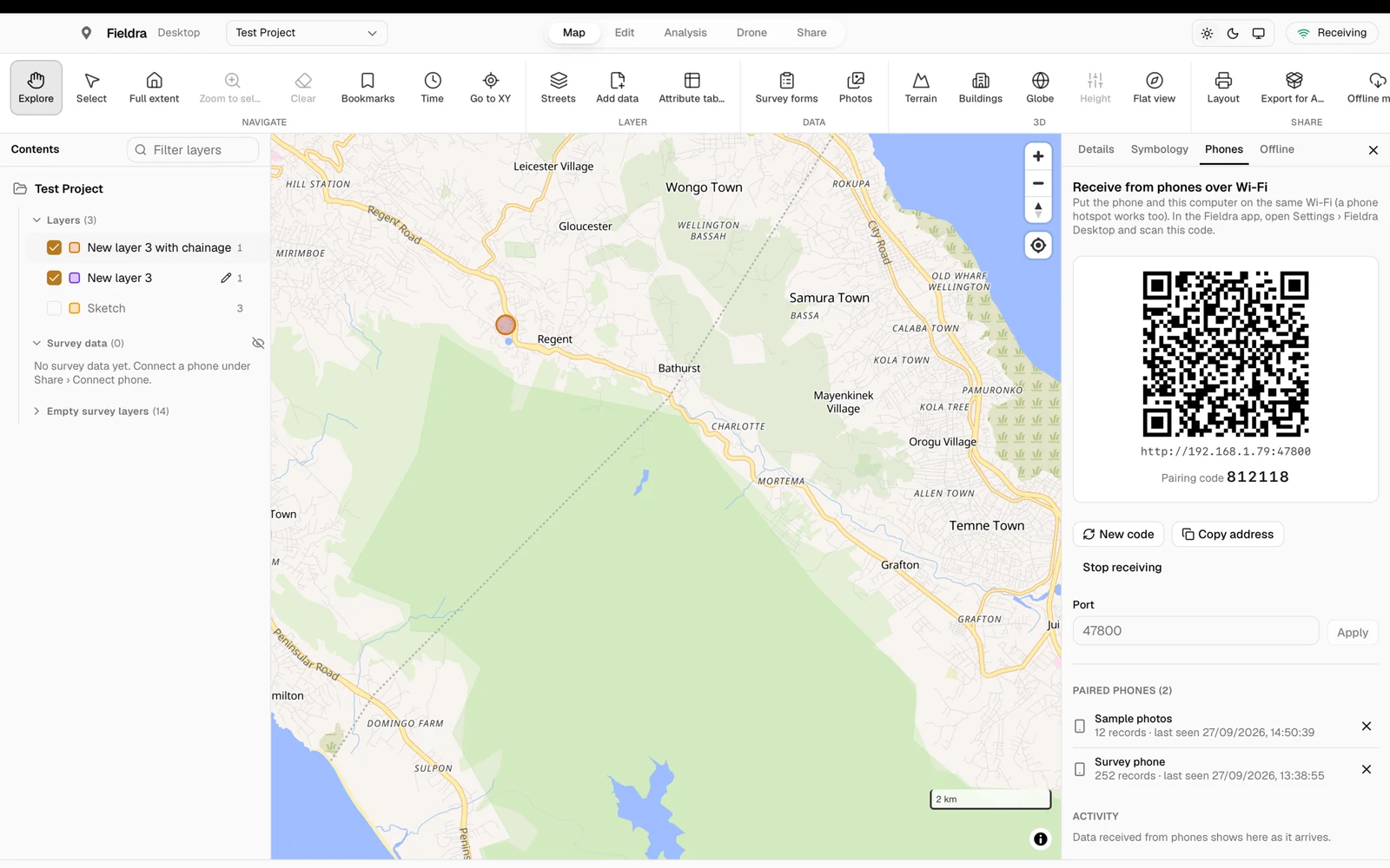
Receive from phones over Wi-Fi
Scan the QR code once with the Fieldra app. Records, form answers and photos then arrive on the same Wi-Fi, even with no internet; you see each item fly across as it lands.
Send whole projects between devices
Nearby devices shows every phone and computer with Fieldra on the network, by name. Pick what to send (whole categories, single records, map layers, with or without photos). Deletions go across too, and if the Wi-Fi drops, it continues where it stopped.
A GIS that works offline
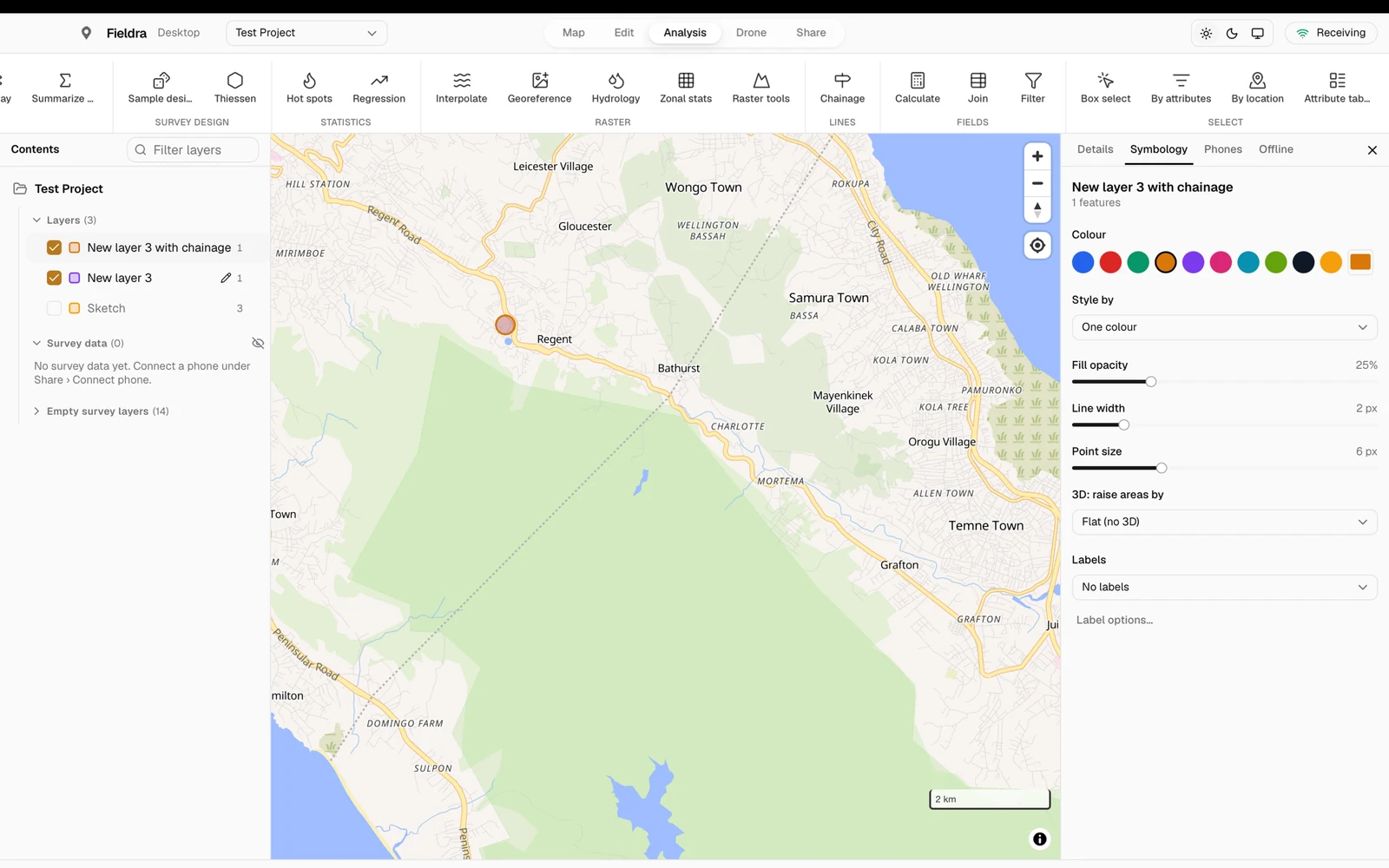
Layers styled by category or graduated colours, heat maps and clusters, an attribute table, drawing and editing with snapping and tracing, bookmarks and a time slider, on street or satellite maps you download for use without internet.
Analysis like ArcGIS Pro
Select by attributes or by location, filter layers, calculate fields and join spreadsheets. Clip, intersect, union, erase, spatial join and summarize within. Interpolate sample points, zonal statistics, slope, hillshade, viewshed and NDVI.
Coordinates and survey tools
Go to any coordinate in degrees, UTM or MGRS. Enter boundaries from bearings and distances (COGO) with their misclosure, give road features their chainage, and georeference a scanned paper map.
Land survey reports
Parcels surveyed on the phones with the compass and any tape arrive with the field book. Check the closure and back bearings, set the declination or a surveyed starting point, and save the survey report with the plan and beacon schedule (WGS 84 and UTM), or add the boundary to the map.
Opens and saves ArcGIS Pro files
Open GeoPackage, Shapefile, Esri JSON, KML, GPX and CSV. Export any layer, or everything at once as one GeoPackage, in WGS 84 or UTM, with the coordinate system recorded. Or hand a whole project to another computer as one package file.
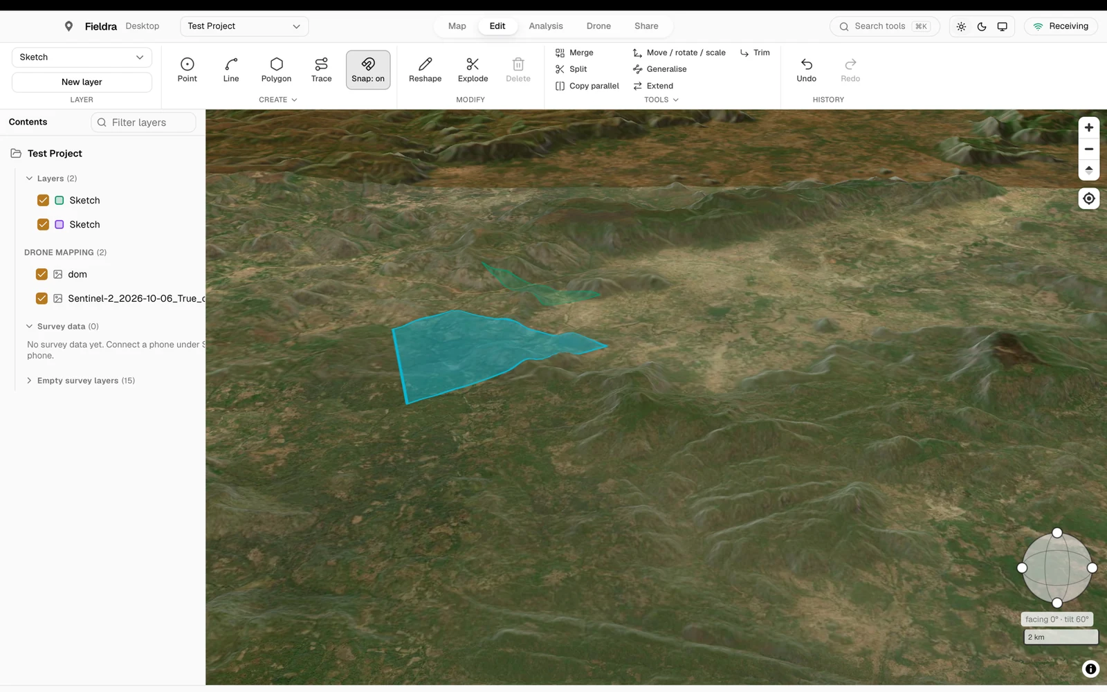
3D terrain, buildings and globe
Tilt the map to see hills and valleys, show buildings in 3D, raise areas by a value, or spin the globe.
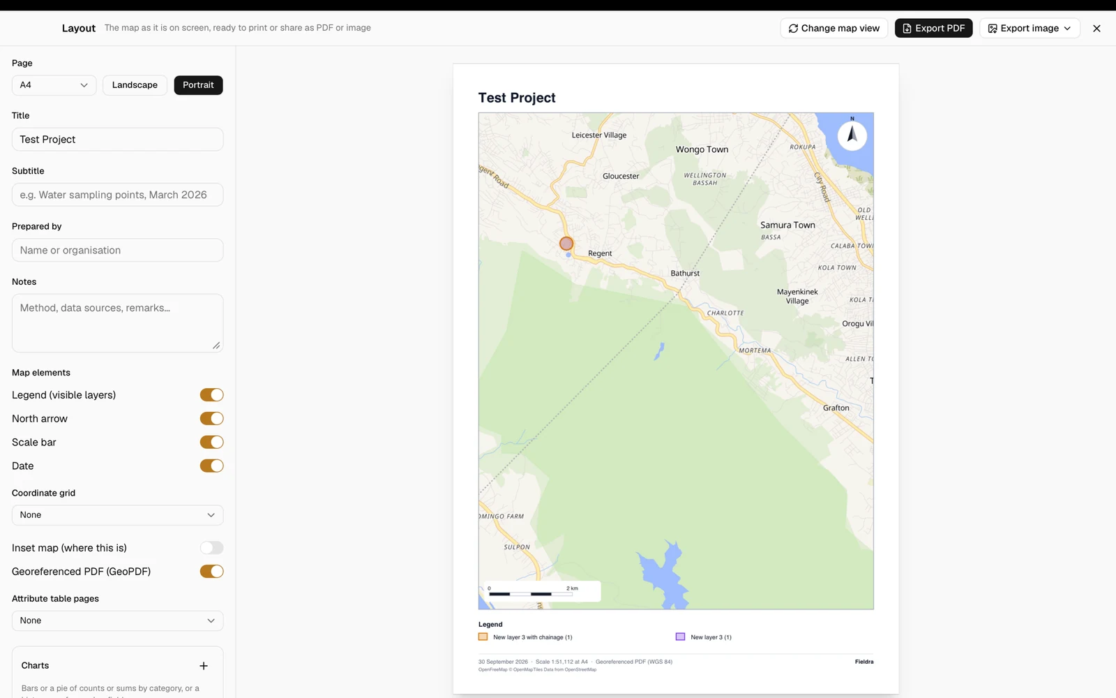
Print layouts
Put the map on a page with a title, legend, north arrow, scale bar, coordinate grid and inset map. Save as PDF, georeferenced PDF, PNG or JPEG, add attribute table pages, or print one page per village or plot.
Survey forms: build, import, report
Build questionnaires on the computer or import XLSForms from KoboToolbox and ODK, send them to the phones, then see a summary of every question and every response, with reports as PDF, Word or CSV.
Dashboard
Charts of the project: records per day and by module, responses by enumerator, sightings by species, and water samples against drinking-water limits, saved as a PDF report.
Projects and photos
Start a project on the computer and send it to the field team. See every photo by category, add your own to a point or the project, and remove what you don't need.
Feels like a desktop app
A full menu bar on the Mac (New Project ⌘N, Add Data ⌘O, Undo that knows whether you’re typing or editing the map), keyboard shortcuts on Windows, and a rename for each computer so the team knows which is which.
Drone tab
Drone mapping, next to DJI Terra and Pix4D
Keep processing the photos in DJI Terra or Pix4D. Fieldra Desktop checks the flight before you start, and afterwards puts the results on the map with your field data, measures volumes and change between flights, and tells you how accurate they are.
Point clouds in 3D
Open LAS or LAZ from DJI Terra, Pix4D, Metashape or a LiDAR payload, on the map with your survey data. Colour by real colour, height, class (ground, buildings, vegetation) or intensity, and click any point for its height.
Orthomosaics and elevation models
GeoTIFF orthomosaics and DSMs (heights shaded with a colour ramp), and MBTiles tile sets. They stay on the computer, so they work with no internet.
Flight check before processing
Choose a flight’s photos to see where each was taken, the ground it covers, the GSD, front and side overlap, how many photos see each patch of ground, and the RTK fix rate — before you spend hours processing.
Accuracy report (ASPRS 2023)
Compare the checkpoints in the model with the ones surveyed by the phones: RMSE horizontal and vertical with the survey error included, the accuracy class, pass or fail against your target, and a PDF report.
Volumes, cross-sections and contours
Draw around a stockpile or a pit and get cut, fill and net volume against the base you choose. Draw a line for the ground profile, or make contour lines at any interval to export for GIS or CAD work.
Compare two dates
Swipe between two flights of the same site, or see them side by side. With two elevation models, see where ground was added or removed and how many cubic metres, for progress, erosion or stockpile checks.
Set up in four steps
- 1
Install it
From the Mac App Store or the Microsoft Store (recommended), or download it from this page. Open it once and allow it on your local network.
- 2
Connect the phones
In the Fieldra app: Settings › Fieldra Desktop, then scan the QR code shown under Phones.
- 3
Survey as usual
Records wait on the phone and go across whenever it is back on the office Wi-Fi.
- 4
Map, check and export
Open the project, check it on the map, and export for ArcGIS Pro, QGIS or a report.
Open your files
Click Add data on the Map tab, or drag the files onto the window. Fieldra sends each file to the right place — a map layer, or the Drone tab. You can choose several files at once, e.g. a shapefile’s parts, or a GeoTIFF with its .ovr.
| You have | How to open it |
|---|---|
| Projects from Fieldra phones | Nothing to open: pair the phone once (Share › Connect phone) and its records and photos arrive over Wi-Fi. |
| A project from another computer (.fieldra) | Share › Open package. |
| GeoPackage (.gpkg) | Add data. Every layer inside is added. |
| Shapefile (.shp) | Add data, and choose the .shp together with its .dbf, .shx and .prj — or a .zip of them. |
| ArcGIS file geodatabase (.gdb) | Share › Open .gdb, then choose the folder ending in .gdb. Or Add data with a .zip of it. Every feature class becomes a layer. |
| Esri JSON, GeoJSON, KML/KMZ, GPX | Add data. |
| CSV or Excel table of points | Add data for a CSV with latitude and longitude (or X and Y) columns. To add columns to an existing layer, use Analysis › Join. |
| Orthomosaic or elevation model (GeoTIFF) | Drone › Orthomosaic, or Add data. If the file doesn’t say its coordinate system, Fieldra asks. |
| Point cloud (LAS, LAZ) | Drone › Point cloud, or Add data. |
| Tiles (MBTiles) | Drone › Orthomosaic, or Add data. Works offline at every zoom. |
| Drone flight photos (JPEG) | Drone › Flight photos, to check overlap, ground size and RTK before processing. |
| A scanned paper map or plan | Analysis › Georeference: match points on the picture to the map, and save it as a GeoTIFF. |
Large orthomosaics open fastest with their overviews
Export a Cloud-Optimised GeoTIFF from DJI Terra (GeoTIFF (COG)), or choose the .ovr file together with the .tif. A 1.5 GB orthomosaic then opens in seconds; on its own it takes a minute or two.
Get Fieldra Desktop
We recommend the Mac App Store and the Microsoft Store: they install the right version for your computer, check it, and keep it up to date. You can also download it straight from this page. Step-by-step instructions for every feature are in the complete guide (PDF).
macOS
Mac App StoreRecommended
Runs on every Mac (Apple silicon and Intel) and updates itself.
Install
- 1Open the Mac App Store page and click Get, then Install.
- 2Open Fieldra from Applications or Launchpad.
- 3Allow it to find devices on your local network when asked, so phones can send it data.
Needs
- macOS 12 Monterey or later
- Apple silicon or Intel processor
- About 100 MB of disk space, plus room for offline maps and drone files
Windows
Microsoft StoreRecommended
Picks the right version for your PC (x64, ARM64 or 32-bit) and updates itself.
Install
- 1Open the Microsoft Store page and click Get (or Install).
- 2Open Fieldra from the Start menu.
- 3Allow it through the firewall on private networks when asked, so phones can send it data.
Needs
- Windows 10 or 11 (64-bit, ARM64 or 32-bit)
- Microsoft Edge WebView2 (built into Windows 11; the Store adds it on Windows 10 if missing)
- About 100 MB of disk space, plus room for offline maps and drone files
Inside Fieldra Desktop
From the project map to a report you can share.
Swipe to explore. Open any screenshot for a closer look.
Or download it directly
The same Fieldra Desktop as in the stores, for a computer without store access or when you need a particular version. It doesn’t update itself: come back here for new versions.
The store is still the better choice
Use the Mac App Store or the Microsoft Store when you can: the store version installs without warnings and updates itself. The direct download works the same, but Windows may show “Windows protected your PC” when you install it; choose More info › Run anyway. On a Mac, if it says it can’t check the app, open System Settings › Privacy & Security and choose Open Anyway.
macOS
- .dmg
Any Mac (Universal)
Runs natively on Apple silicon and Intel Macs. Pick this if you are not sure.
- .dmg
Apple silicon
Macs with an M1, M2, M3 or M4 chip (most Macs from 2021 on). Smaller download.
- .dmg
Intel
Macs with an Intel processor (most Macs before 2021).
Install
- 1Open the downloaded .dmg and drag Fieldra into Applications.
- 2Open Fieldra from Applications. If macOS says it can’t check the app, open System Settings › Privacy & Security and choose Open Anyway.
- 3Allow it to find devices on your local network when asked, so phones can send it data.
Windows
- Installer .exe
Any Windows PC (installer)
One installer for 64-bit Intel/AMD and ARM PCs; it installs the right one. Pick this if you are not sure.
- Installer .exe
64-bit (x64)
Most Windows 10 and 11 PCs with an Intel or AMD processor.
- Installer .exe
ARM64
Windows on ARM, e.g. Surface Pro X and Copilot+ PCs with Snapdragon chips.
- Portable .zip
32-bit (x86)
Older PCs running 32-bit Windows 10. Portable: unzip and run, no install.
- Portable .zip
64-bit (x64), portable
No installer: unzip and run, e.g. from a USB stick or without admin rights.
- Portable .zip
ARM64, portable
No installer: unzip and run.
Install
- 1Run the installer (or unzip the portable version and open Fieldra.exe).
- 2If Windows shows “Windows protected your PC”, choose More info › Run anyway.
- 3Allow Fieldra through the firewall on private networks when asked, so phones can send it data.
Guides
Read them online or download them to keep on your phone or computer.
For field teams and office staff
Complete guide
How to use the phone app, Fieldra Desktop and drone mapping, step by step in plain words, with pictures.
PDF · 84 pages · Updated 16 October 2026
For developers and technical teams
Technical guide
Architecture, processing engines, data storage, recovery behavior and measured performance limits.
PDF · 35 pages · Updated 16 October 2026
For testers and project leads
Test script
Step-by-step checks with expected results, including interrupted processing, retries and large datasets.
PDF · 63 pages · Updated 16 October 2026
For teams choosing their workflow
Capabilities and limitations
A feature comparison with ArcGIS and QGIS, with current gaps and limits to help plan project work.
PDF · 28 pages · Updated 16 October 2026